 Michael Jackson (Image via RottenTomatoes.com)
 Image via Wikipedia
 Image via Wikipedia
 IMG_1673 (Photo credit: The National Academy of Sciences)
The Georgia Guidestones
Twelve Things You Were Not Taught in School About Creative Thinking
Michael Michalko
The only difference between people who are creative and people who are not is a simple belief. Creative people believe they are creative
You must have passion and the determination to immerse yourself in the process of creating new and different ideas. Then you must have patience to persevere against all adversity. All creative geniuses work passionately hard and produce incredible numbers of ideas, most of which are bad. In fact, more bad poems were written by the major poets than by minor poets.
The more times you try to get ideas, the more active your brain becomes and the more creative you become.
Your brain is a dynamic system that evolves its patterns of activity rather than computes them like a computer. It thrives on the creative energy of feedback from experiences real or fictional. You can synthesize experience; literally create it in your own imagination. The human brain cannot tell the difference between an "actual" experience and an experience imagined vividly and in detail.
Reality is ambiguous. Think of all your ideas as possibilities and generate as many as you can before you decide which ones to select. The world is not black or white. It is grey.
Experts will spend all their time showing and explaining why it can't be done and why it can't work. They will not look for ways to make it work or get it done
Don't allow yourself to get discouraged. Whenever you try to do something and do not succeed, you do not fail. You have learned something that does not work.

Arid lands are among the world’s most fragile ecosystems, made more so by periodic droughts and increasing overexploitation of meagre resources. Arid and semi-arid lands cover around one-third of the world’s land area and are inhabited by about one billion people, a large proportion of whom are among the poorest in the world.
Forests, trees and grasses are essential constituents of arid zone ecosystems and contribute to maintaining suitable conditions for agriculture, rangeland and human livelihoods. In providing goods (especially fuelwood and non-wood products) and environmental services to the rural poor and in contributing to the diversification of their household sources of income, forests and trees in arid zones boost poverty alleviation strategies and reduce food insecurity.
Roughly 6 percent of the world’s forest area (about 230 million hectares) is located in arid lands (FAO, 2001). Trees outside forests (scattered in the landscape, in arable lands, in grazing lands, in savannahs and steppes, in barren lands and in urban areas) have a vital role in arid lands, although it is difficult to assess their extent.
Availability of water – surface water, groundwater and air moisture – is usually the main factor limiting natural distribution of trees in arid lands, along with climate (rainfall, temperatures, wind) and soil quality. Each tree species is adapted to certain conditions and is located in its “niche”. When optimal conditions are widely distributed, forests or shrubs may cover large areas. More often, limited by water scarcity, vegetation is concentrated where runoff can accumulate or where groundwater is accessible. This leads to the uneven distribution of trees and bushes, for example in striped bush (fragmented bush stands), riparian forests, the deepest channels of valleys (thalwegs) and oases, and isolated in the landscape.
However, the natural distribution of vegetation has long been altered by human activities. Deforestation and degradation of tree and shrub formations (mainly through conversion to agricultural use) and overexploitation of forests and woodlands (through fuelwood collection and overgrazing) are among the major causes of soil degradation in arid areas.Conversion of forests for agricultural crops and pasture land is the main cause of the increasing deforestation in arid lands. In many places the prevailing shifting cultivation and crop/fallow systems are no longer possible and continuous cultivation of the same piece of land, often with no crop rotation, leads to exhaustion of soil fertility and the need for new lands. Degraded wooded lands which were formerly neglected are now actively deforested. Increased grazing pressure and unmanaged harvesting of fuelwood and other products also result in degradation and deforestation.
Great importance is given to chemical analyses, to work on the nutrient cycles in the environment and on changes in the chemical composition of soil and water. This is particularly true in studies of the far-reaching effects of salinization. There is a very interesting methodological approach in describing the salt cycle in the environment, which also takes the atmosphere into account (salt deflation, salinization in connection with winds over salty lands
There is an interesting group of work on «formerly irrigated lands» in Central Asia. The irrigated lands of the past (especially in the 13th and 14th centuries, occasionally until the middle of the 19th) were much more extensive than those irrigated today. Specialists consider these lands particularly suitable for future irrigation. For this reason they have been identified (using remote sensing, and other methods), and their soils are scrupulously studied.
The uniqueness of the process of desertification in the ex-USSR is due to the fact that it is related to enormous programmes of desert "conquest" and management, characteristic of the Soviet period. These include: (i) the transformation of the steppe into arable land; and (ii) the construction of extensive irrigation systems and the development of the monoculture of cotton in Central Asia.
Although agriculture began in the steppes several centuries ago, it is only the programmes started in 1954 which have had a significant effect on the natural environment. In the first six years, 40 million hectares were ploughed by large, heavy tractors. After 1960, ploughing in the steppes slowed as the activity moved east. After ploughing the steppes in the European part of the USSR, work began in Kazakhstan and in southern Siberia. Today, approximately 75% of the total surface of the steppes has been ploughed. A large part of the steppes later became unfit for cultivation. 3.18 Irrigation development programmes were not begun with the same enthusiasm, although they intensified in the 1970's and early 1980's.
3.19 In the entire USSR, the surface area irrigated increased from 10.8 million hectares in 1970, to 17.5 million hectares in 1980, 19.9 million hectares in 1985 and 21.2 million hectares in 1990. This of course required an enormous water collection, which in 1988 was a total of 152.5 km3 divided by 46.2 km3 in Uzbekistan, 24.4 km3 in Kazakhstan, 23.3 km3 in the Federal Republic of Russia, 18.2 km3 in Turkmenistan, 9.1 km3 in Kyrgyzstan, and 8.7 km3 in Azerbaijan.
3.20 In the USSR the consumption of irrigation water in drylands was very high, on the average 8,900 m3/ha, with at least 13,300 m3/ha in Armenia, 13,200 m3 in Uzbekistan, and 12,800 m3 in Kazakhstan (according to Russian statistics, cf. bibl. entry 54).
3.21 During the 1960's, efforts were directed towards the implementation of a global management programme for the Golodnaïa Stïep' (the Steppe of Hunger) in Uzbekistan. This initiative was to be a model of modifying nature (cf. bibl. entries 12, 46, 67, 86). In the years 1923-1956 about 250,000 ha were irrigated. In order to irrigate an additional 246,000 ha, construction was begun in 1956 on the Golodnaïa Stïep Canal, with a main branch of 246 km in length, plus lateral canals. At the same time, constructions were begun on drainage canals, villages, railroads (93 km), roads (1,746 km), gas pipelines, cotton factories, etc. In the years 1961-1972, cotton harvests in the USSR increased by 650,000 tonnes, almost half of which came from the Golodnaïa Steppe. The population increased rapidly, reaching, in 1974, 113,000 (in 1878 the population was 2,000).
3.22 The Karakumy Canal (or V.I. Lenin Canal) was the other large project begun in 1954. The canal, which in the USSR was considered to be "the largest hydrotechnical construction in the world" measures 1,200 km in length (it was supposed to be 1,400 km but its last part was not completed). It collects water from the Amu-Darya (400m3/s) and takes it towards the oases of Murgab, Tedzhen, and other smaller ones in the Kopet Dag foothills. It is supplemented by approximately 2,000 km of small canals. Along the canal, 55 large state farms have been created, with areas from 27,000 to 650,000 ha each (cf. bibl. entries 12, 46, 49, 67). In addition to the development of irrigated agriculture, there is also a marked increase in livestock production in Central Asia.
3.23 However, the GNP per ha of irrigated lands, which increased from 1,430 roubles/ha in 1970 to 1,715 roubles/ha in 1980, has diminished since, in some republics even to levels lower than those recorded in 1970. Desertification caused by human action is very likely one of the causes of this decrease.
It has not been possible to find a publication which presents in a complete way the phenomena of desertification in the USSR. Based on various publications (cf. Index), the most important phenomena of desertification are (i) the deflation and mobilization of dunes; (ii) the salinization of soil; and (iii) the degradation of vegetation, notably around wells.
Soil salinization in the ex-USSR has reached levels which probably exceed any elsewhere
Large white patches of solonchaks, just outside the irrigated zones, are visible both by train and by plane.
..... it is without doubt human activity, especially errors made in the management of arid and semi-arid lands, which is the chief factor in present-day desertification.
Losses of irrigation water due to evaporation and infiltration from canals hundreds of km long, sometimes dug in permeable sand, are enormous. For example, in the area around the Karakumy Canal, several small lakes have formed. Rapid evaporation leads directly to salinization
The main factors in wind erosion are believed to be the ploughing of the steppes and over-grazing.
It is only in very recent years that information has been published on the direct dangers for human health. The health of the inhabitants of the Aral Sea region is in a disastrous state from dust and salt in the air, the high salt levels of drinking water (sometimes over 10/1000), and drinking water that is polluted by mineral fertilizers and herbicides. The results are a high number of contagious diseases (especially typhus and gastro-intestinal illnesses), several eye diseases (most children there wear glasses), a very high infant mortality rate (around 10%, which is higher than the average in the ex-USSR or in Asian countries
Characterized by the barrenness of the soil and the loss of biological species, desertification has the following consequences:
- the loss of an important part of the ecological heritage
- the significant decrease of the agricultural production
- the increase of food insecurity
- the increase of the populations' poverty and misery
- the increase of rural exodus
- the break-up of families leaving their lands and the loss of cutural identity
In Burkina Faso, development is closely related to the fight against desertification. More than half of the national territory is already affected in a significant way by this disaster which is progressing.
Green Cross Burkina Faso, a member of Green Cross International since 1995, has launched a large scale programme for fighting against desertification. This project named for the Sahel » and implemented with the close collaboration of the local populations is clearly innovating.
The project will last 5 years and, besides tree planting, includes the creation of nurseries of young plants, as well as the following activities:
- tree planting by the populations concerned
- Information and dissemination of local populations of through complete and adequate information
- the supervision of plants'growth
- the resort to solutions for a better use of fuelwood (fuel saving stoves) and merely replacing it
What makes the project specific is the fact that it includes the creation of three nurseries for the production of plants, under the management of the populations themselves, the final users.
With the creation of those nurseries, the project aims at:
- making plants available in sufficient quantities
- producing common or uncommon trees species
So, each of the 3 provinces involved in the project ( the Comoé, Yatenga and Kadiogo provinces) will have its own nursery.
Those nurseries will also be used as nurseries », places where children will be trained to the techniques of plant production and tree planting. In this respect, the nurseries will be equipped in order to meet the objectives aimed at (amusement parks, botanical gardens, etc.).
The selected tree species vary according to the areas where they are planted. Therefore, certain species may not be selected either for the Comoé, Yatenga or Kadiogo. The selection of tree species is made in close collaboration with the local populations after a consultation process.
2. OBJECTIVES
The project for the Sahel » aims at successfully carrying out all activities relating to afforestation in order to stop the progress of desertification in certain areas of Burkina Faso.
The project is clearly designed to be a continuation process and will last 5 years.
Concrete objectives aimed at:
- The planting of more than 370 000 trees of various species adapted to the differents regions, in protected as well as unprotected areas
- Information and dissemination of populations for a better maintenance of plants and afforested areas and a better management of plant resources
- Supplying of wood as a renewable raw material for a long-lasting use
- The creation of supplementary income for the local populations through the production of Arabic gum as a raw material.
The production and selling of plants adapted to local conditions, the dissemination of the techniques and know-how acquired will enable the initiators of the project to generate substantial and long-lasting incomes.
The experience acquired during the 5 years of the project will be used as a basis for expanding it to other regions of Burkina Faso as well as other regions of Africa affected by desertification.
3. PARTNERS
Several national organizations of the Green Cross network have shown deep interest for the project for the Sahel » developed by Green Cross Burkina Faso. Other organizations, members of the network, are faced with the consequences of desertification in their own countries ; this is the case of Russia, Argentina, Bolivia, Swaziland.
Desertification in the Sahel
Case studies in water resource management
Water policies contributed to the trend in decreasing food security in many of the countries of the Arab region in the short run and to an overexploitation of the natural resource base, on which agriculture and indeed the economy depends, in the long term. In addition, the pressure of population, which is growing at an average rate of about 3 percent in the region, has increased the vulnerability of the economies of most countries of the Arab region.
Desertification: A review of the
Twelve Things You Were Not Taught in School About Creative Thinking
Michael Michalko
The only difference between people who are creative and people who are not is a simple belief. Creative people believe they are creative
You must have passion and the determination to immerse yourself in the process of creating new and different ideas. Then you must have patience to persevere against all adversity. All creative geniuses work passionately hard and produce incredible numbers of ideas, most of which are bad. In fact, more bad poems were written by the major poets than by minor poets.
The more times you try to get ideas, the more active your brain becomes and the more creative you become.
Your brain is a dynamic system that evolves its patterns of activity rather than computes them like a computer. It thrives on the creative energy of feedback from experiences real or fictional. You can synthesize experience; literally create it in your own imagination. The human brain cannot tell the difference between an "actual" experience and an experience imagined vividly and in detail.
Reality is ambiguous. Think of all your ideas as possibilities and generate as many as you can before you decide which ones to select. The world is not black or white. It is grey.
Experts will spend all their time showing and explaining why it can't be done and why it can't work. They will not look for ways to make it work or get it done
Don't allow yourself to get discouraged. Whenever you try to do something and do not succeed, you do not fail. You have learned something that does not work.
Neotame, New Neurotoxic Sweetener: FDA Says No Label Needed, Not Even in Organics | Locals Supportin
www.localssupportinglocals.caAspartame can step aside. There's a new sweetener in town and it isn't saddled with the inconvenience of having to be listed on labels, so it can be sneaked into any prepared food, even USDA so-called Organic. So sayeth the FDA. Neotame is a Monsanto-created chemical similar to Aspartame, includ...
Desertification is of particular interest to climatologists in their attempts to understand climate variation and change on both short and long time scales (e.g. Hare, 1976). With increasing pressure on governmental decision-makers to allow populations to move into the climatically marginal areas, the implications of natural variations in climate have become even more important in decisions relating to the use by society of its land in these desertification-prone regions. One can easily assert that there will always be climatic deserts. However, man-induced extensions of these deserts or the creation of desert-like conditions in areas where they had not existed can and must be avoided.
DESERTIFICATION OF ARID LANDS - Center
(from page 2)
The decade of the 1950's witnessed the first worldwide effort to call attention to the problems and potentials of arid regions. It started when the United Nations Educational, Scientific, and Cultural Organization (UNESCO) launched its Major Project on Scientific Research on Arid Lands in 1951. That project led to publication of a newsletter, the provision for funds for establishing and strengthening arid land research institutes, organization of conferences and symposia, and publication of a series of research reviews and special reports on a wide range of topics. The Major Project was terminated in 1962 and the arid land program was merged with the broader UNESCO natural resource program.
The impetus generated by the UNESCO project led to expanded interest in, and support of, arid lands studies throughout the world. By 1970, knowledgeable scientists were well aware of the magnitude of the land destruction that had taken place in the past, and that was becoming even more serious as population pressures increased.
At about the same time, one event served to focus world attention on desertification: the 1969 to 1973 drought in the African Sahel. Recognition of the severity of the drought affecting six countries on the southern border of the Sahara (Mauritania, Senegal, Mali, Upper Volta, Niger, and Chad) was slow to develop. Droughts, after all, were not unusual in the Sahelian countries; an equally bad or even worse one had struck the same region during the years from 1911 to 1914, and several other droughts had occurred before and after that time. It was only when the situation had become catastrophic that relief measures were undertaken on a large scale.
Desertification:
A review of the concept
Desertification is acknowledged to be a complex phenomenon requiring the expertise of researchers in such disciplines as climatology, soil science, meteorology, hydrology, range science, agronomy, veterinary medicine, as well as geography, political science, economics and anthropology. It has been defined in many different ways by researchers in these and other disciplines, as well as from many national and bureaucratic (institutional) perspectives, each emphasizing different aspects of the phenomenon.Desertification is of particular interest to climatologists in their attempts to understand climate variation and change on both short and long time scales (e.g. Hare, 1976). With increasing pressure on governmental decision-makers to allow populations to move into the climatically marginal areas, the implications of natural variations in climate have become even more important in decisions relating to the use by society of its land in these desertification-prone regions. One can easily assert that there will always be climatic deserts. However, man-induced extensions of these deserts or the creation of desert-like conditions in areas where they had not existed can and must be avoided.

Desertification is increasing
Countries, particularly developing countries, with arid and semi-arid areas or areas that are subject to floods, drought and desertification are especially vulnerable to the adverse effects of climate change...... other mechanisms, particularly deforestation and agricultural practices, are major influences.
Desertification has been a long-standing problem in many areas of the world. It is particularly pronounced in Africa, where Mauritania provides an extensively studied example, where it has been found that:In China, the Kumtag desert is expanding by one to four metres eastward annually. In southern Europe, desertification and related loss of productive capacity has worsened considerably over the last few decades.The climate has altered drastically since the onset of the prolonged drought in the 1960s, part of a recurrent pattern of wet and dry cycles common to Sahelian Africa. Experts agree, however, that overgrazing, deforestation, denuding of ground cover around wells, poor farming methods, and overpopulation have aggravated the drought. In Mauritania the isohyet [geographic line of constant rainfall] indicating annual rainfall of 150 millimeters—considered the minimum for pastoralism—has shifted southward about 100 kilometers. During the 1980s, the desert was advancing southward at an estimated rate of six kilometers a year. Each major climatic zone had shifted southward.
Source: Robert E. Handloff, ed., 'Expansion of the desert', Mauritania—a country study, GPO for the Library of Congress, Washington, 1988.
DESERTIFICATION OF ARID LANDS - Center
(from page 2)A second misconception is that droughts are responsible for desertification. Droughts do increase the ... worse, particularly in the Sahel, by the drilling of additional wells ...
ciesin.org/docs/002-193/002-193.html The decade of the 1950's witnessed the first worldwide effort to call attention to the problems and potentials of arid regions. It started when the United Nations Educational, Scientific, and Cultural Organization (UNESCO) launched its Major Project on Scientific Research on Arid Lands in 1951. That project led to publication of a newsletter, the provision for funds for establishing and strengthening arid land research institutes, organization of conferences and symposia, and publication of a series of research reviews and special reports on a wide range of topics. The Major Project was terminated in 1962 and the arid land program was merged with the broader UNESCO natural resource program.
The impetus generated by the UNESCO project led to expanded interest in, and support of, arid lands studies throughout the world. By 1970, knowledgeable scientists were well aware of the magnitude of the land destruction that had taken place in the past, and that was becoming even more serious as population pressures increased.
At about the same time, one event served to focus world attention on desertification: the 1969 to 1973 drought in the African Sahel. Recognition of the severity of the drought affecting six countries on the southern border of the Sahara (Mauritania, Senegal, Mali, Upper Volta, Niger, and Chad) was slow to develop. Droughts, after all, were not unusual in the Sahelian countries; an equally bad or even worse one had struck the same region during the years from 1911 to 1914, and several other droughts had occurred before and after that time. It was only when the situation had become catastrophic that relief measures were undertaken on a large scale.
A definition of desertification should recognize that it is a land degradation process that involves a continuum of change, from slight to very severe degradation of the plant and soil resource, and is due to man's activities.
Overgrazing inadvertently was made worse, particularly in the Sahel, by the drilling of additional wells that provided drinking water for livestock throughout the year. Without the rest period that intermittent water supplies previously assured, forage conditions deteriorated around the wells where water was no longer a limiting factor in livestock survival. Local authorities did not or could not impose a control system that would allow forage plants to recover from heavy grazing.
A crude estimate of the amount of crop yield reduction that could be attributed to salinization and waterlogging in the Nile Valley indicates it to be at least 17 percent on 80 to 90 percent of the old irrigated land. In the newly irrigated lands east and west of the delta, the figure is likely to be a minimum of 25 percent yield reduction. Both problems are serious ones that can become even more serious in the future if remedial measures are not taken. The situation in Algeria and Tunisia is similar to that in Egypt with respect to yield reductions.
Solutions to desertification problems in Africa are known-- and in general--can be implemented readily if resources are available to do so. An exploding population in the developing countries, however, means that land pressures will continue to build. Reducing livestock numbers in the grazing lands until forage productivity can be improved is very difficult, at best, and introducing range use controls on communal land is not easy. There is little likelihood that marginal dryfarm lands will be returned to pastoral use unless production on the better lands is increased enough to offset the loss of cultivated land. While the latter can be done, progress in that direction is very slow.
Destruction of woody vegetation has been hastened by the ever-increasing need for firewood to meet the demands of the larger population. The destruction is especially noticeable around the rapidly growing urban centers, where the circle of deforested lands gets larger every year (Delwaulle, 1973).
While desertification was a long-standing problem even in the absence of droughts, the gradually increasing vulnerability of the land made the impact of the inevitable droughts worse than ever (Dahl and Hjort, 1979). The factors responsible for that vulnerability are still operating, desertification continues, and future droughts will have ever-greater damaging effects.
Salt-affected soils are common in Tunisia and Algeria where both surface and well irrigation waters frequently are saline. Salinization is important in other irrigated areas but on a small scale.
Magnitude of Desertification
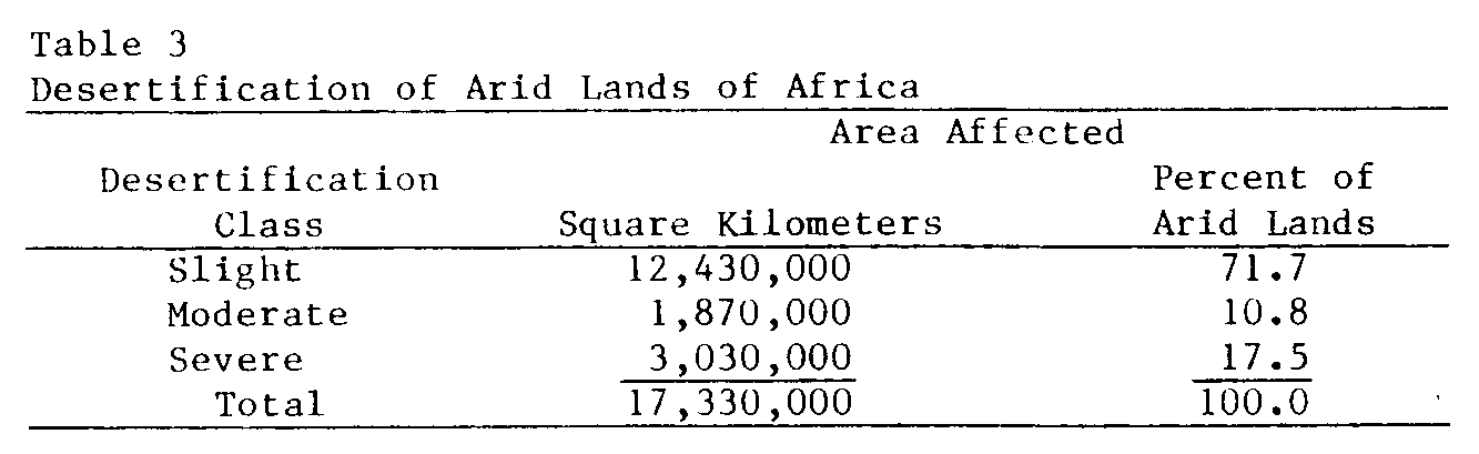
About 18 percent of the arid region of Africa is severely desertified, and most of that represented by grazing lands and rain-fed cropping lands on the south side of the Sahara (Table 3). The other large area that is severely affected is the mountain slopes and the plains of North Africa. Moderate to high salinity affects about 30 percent of the irrigated land in Egypt (Aboukhaled et al., 1975).
Wind erosion is dominant in the drier regions and water erosion on the wetter sloping lands. Ethiopia, Kenya, and the Maghreb countries of Algeria, Morocco, and Tunisia have been subjected to especially serious water erosion, whereas wind erosion has been most damaging in sub-Saharan West Africa. While good data on the effect of land degradation on crop and livestock yields are not available, it seems likely that soil fertility losses, alone, have reduced dryland crop yields by 25 to 50 percent in the severely desertified areas. Animal productivity may well have declined by at least 50 percent nearly everywhere that domestic livestock are raised. In many areas south of the Sahara, rangeland forage production probably is less than 25 percent of the potential.
A crude estimate of the amount of crop yield reduction that could be attributed to salinization and waterlogging in the Nile Valley indicates it to be at least 17 percent on 80 to 90 percent of the old irrigated land. In the newly irrigated lands east and west of the delta, the figure is likely to be a minimum of 25 percent yield reduction. Both problems are serious ones that can become even more serious in the future if remedial measures are not taken. The situation in Algeria and Tunisia is similar to that in Egypt with respect to yield reductions.
Solutions to desertification problems in Africa are known-- and in general--can be implemented readily if resources are available to do so. An exploding population in the developing countries, however, means that land pressures will continue to build. Reducing livestock numbers in the grazing lands until forage productivity can be improved is very difficult, at best, and introducing range use controls on communal land is not easy. There is little likelihood that marginal dryfarm lands will be returned to pastoral use unless production on the better lands is increased enough to offset the loss of cultivated land. While the latter can be done, progress in that direction is very slow.
Destruction of woody vegetation has been hastened by the ever-increasing need for firewood to meet the demands of the larger population. The destruction is especially noticeable around the rapidly growing urban centers, where the circle of deforested lands gets larger every year (Delwaulle, 1973).
While desertification was a long-standing problem even in the absence of droughts, the gradually increasing vulnerability of the land made the impact of the inevitable droughts worse than ever (Dahl and Hjort, 1979). The factors responsible for that vulnerability are still operating, desertification continues, and future droughts will have ever-greater damaging effects.
Salt-affected soils are common in Tunisia and Algeria where both surface and well irrigation waters frequently are saline. Salinization is important in other irrigated areas but on a small scale.
Magnitude of Desertification
About 18 percent of the arid region of Africa is severely desertified, and most of that represented by grazing lands and rain-fed cropping lands on the south side of the Sahara (Table 3). The other large area that is severely affected is the mountain slopes and the plains of North Africa. Moderate to high salinity affects about 30 percent of the irrigated land in Egypt (Aboukhaled et al., 1975).
Wind erosion is dominant in the drier regions and water erosion on the wetter sloping lands. Ethiopia, Kenya, and the Maghreb countries of Algeria, Morocco, and Tunisia have been subjected to especially serious water erosion, whereas wind erosion has been most damaging in sub-Saharan West Africa. While good data on the effect of land degradation on crop and livestock yields are not available, it seems likely that soil fertility losses, alone, have reduced dryland crop yields by 25 to 50 percent in the severely desertified areas. Animal productivity may well have declined by at least 50 percent nearly everywhere that domestic livestock are raised. In many areas south of the Sahara, rangeland forage production probably is less than 25 percent of the potential.
FAO Corporate Document Repository
Forests, trees and water in arid lands: a delicate balance
Michel Malagnoux, prior to his retirement in September 2007, was Forestry Officer (Arid Zones) in the Forest Conservation Service, FAO Forestry Department.
El Hadji Sène was Director of the Forest Resources Division, FAO Forestry Department, until his retirement in 2004, and currently resides in Dakar, Senegal.
Nir Atzmon is in the Department of Agronomy and Natural Resources, Institute of Field and Garden Crops, Agriculture Research Organization, Volcani Centre, Bet-Dagan, Israel.This article is adapted from Malagnoux, 2007.
In arid lands, where competition for water is acute, trees should be planted only when and where necessary and possible.
( In the land clearing in the Amazon, deforestation is cited as a cause of drought, as the presence of trees affects weather and rainfall. )Arid lands are among the world’s most fragile ecosystems, made more so by periodic droughts and increasing overexploitation of meagre resources. Arid and semi-arid lands cover around one-third of the world’s land area and are inhabited by about one billion people, a large proportion of whom are among the poorest in the world.
Forests, trees and grasses are essential constituents of arid zone ecosystems and contribute to maintaining suitable conditions for agriculture, rangeland and human livelihoods. In providing goods (especially fuelwood and non-wood products) and environmental services to the rural poor and in contributing to the diversification of their household sources of income, forests and trees in arid zones boost poverty alleviation strategies and reduce food insecurity.
Roughly 6 percent of the world’s forest area (about 230 million hectares) is located in arid lands (FAO, 2001). Trees outside forests (scattered in the landscape, in arable lands, in grazing lands, in savannahs and steppes, in barren lands and in urban areas) have a vital role in arid lands, although it is difficult to assess their extent.
Availability of water – surface water, groundwater and air moisture – is usually the main factor limiting natural distribution of trees in arid lands, along with climate (rainfall, temperatures, wind) and soil quality. Each tree species is adapted to certain conditions and is located in its “niche”. When optimal conditions are widely distributed, forests or shrubs may cover large areas. More often, limited by water scarcity, vegetation is concentrated where runoff can accumulate or where groundwater is accessible. This leads to the uneven distribution of trees and bushes, for example in striped bush (fragmented bush stands), riparian forests, the deepest channels of valleys (thalwegs) and oases, and isolated in the landscape.
However, the natural distribution of vegetation has long been altered by human activities. Deforestation and degradation of tree and shrub formations (mainly through conversion to agricultural use) and overexploitation of forests and woodlands (through fuelwood collection and overgrazing) are among the major causes of soil degradation in arid areas.
Conversion of forests for agricultural crops and pasture land is the main cause of the increasing deforestation in arid lands. In many places the prevailing shifting cultivation and crop/fallow systems are no longer possible and continuous cultivation of the same piece of land, often with no crop rotation, leads to exhaustion of soil fertility and the need for new lands. Degraded wooded lands which were formerly neglected are now actively deforested. Increased grazing pressure and unmanaged harvesting of fuelwood and other products also result in degradation and deforestation.
Rising Salinity and Water Shortages in Gaza (Green Prophet)
Gazan Farmers Struggle With Rising Salinity & Water Shortages Arwa Aburawa High water demand is putting pressure on scarce water resources and destroying the agricultural sector in Gaza Water shortages are a widespread and common problem … Continue reading
Desertification and drylands development in CIScountries
Authors in the ex-USSR and the CIS of today commonly use the concept of desertification caused by technology leading to the degradation of ecosystems in arid and semi-arid zones. This degradation results, for example, from road construction, railways, mines and other large infrastructures. This type of desertification is very widespread in the countries of the USSR/CISGreat importance is given to chemical analyses, to work on the nutrient cycles in the environment and on changes in the chemical composition of soil and water. This is particularly true in studies of the far-reaching effects of salinization. There is a very interesting methodological approach in describing the salt cycle in the environment, which also takes the atmosphere into account (salt deflation, salinization in connection with winds over salty lands
There is an interesting group of work on «formerly irrigated lands» in Central Asia. The irrigated lands of the past (especially in the 13th and 14th centuries, occasionally until the middle of the 19th) were much more extensive than those irrigated today. Specialists consider these lands particularly suitable for future irrigation. For this reason they have been identified (using remote sensing, and other methods), and their soils are scrupulously studied.
The uniqueness of the process of desertification in the ex-USSR is due to the fact that it is related to enormous programmes of desert "conquest" and management, characteristic of the Soviet period. These include: (i) the transformation of the steppe into arable land; and (ii) the construction of extensive irrigation systems and the development of the monoculture of cotton in Central Asia.
Although agriculture began in the steppes several centuries ago, it is only the programmes started in 1954 which have had a significant effect on the natural environment. In the first six years, 40 million hectares were ploughed by large, heavy tractors. After 1960, ploughing in the steppes slowed as the activity moved east. After ploughing the steppes in the European part of the USSR, work began in Kazakhstan and in southern Siberia. Today, approximately 75% of the total surface of the steppes has been ploughed. A large part of the steppes later became unfit for cultivation. 3.18 Irrigation development programmes were not begun with the same enthusiasm, although they intensified in the 1970's and early 1980's.
3.19 In the entire USSR, the surface area irrigated increased from 10.8 million hectares in 1970, to 17.5 million hectares in 1980, 19.9 million hectares in 1985 and 21.2 million hectares in 1990. This of course required an enormous water collection, which in 1988 was a total of 152.5 km3 divided by 46.2 km3 in Uzbekistan, 24.4 km3 in Kazakhstan, 23.3 km3 in the Federal Republic of Russia, 18.2 km3 in Turkmenistan, 9.1 km3 in Kyrgyzstan, and 8.7 km3 in Azerbaijan.
3.20 In the USSR the consumption of irrigation water in drylands was very high, on the average 8,900 m3/ha, with at least 13,300 m3/ha in Armenia, 13,200 m3 in Uzbekistan, and 12,800 m3 in Kazakhstan (according to Russian statistics, cf. bibl. entry 54).
3.21 During the 1960's, efforts were directed towards the implementation of a global management programme for the Golodnaïa Stïep' (the Steppe of Hunger) in Uzbekistan. This initiative was to be a model of modifying nature (cf. bibl. entries 12, 46, 67, 86). In the years 1923-1956 about 250,000 ha were irrigated. In order to irrigate an additional 246,000 ha, construction was begun in 1956 on the Golodnaïa Stïep Canal, with a main branch of 246 km in length, plus lateral canals. At the same time, constructions were begun on drainage canals, villages, railroads (93 km), roads (1,746 km), gas pipelines, cotton factories, etc. In the years 1961-1972, cotton harvests in the USSR increased by 650,000 tonnes, almost half of which came from the Golodnaïa Steppe. The population increased rapidly, reaching, in 1974, 113,000 (in 1878 the population was 2,000).
3.22 The Karakumy Canal (or V.I. Lenin Canal) was the other large project begun in 1954. The canal, which in the USSR was considered to be "the largest hydrotechnical construction in the world" measures 1,200 km in length (it was supposed to be 1,400 km but its last part was not completed). It collects water from the Amu-Darya (400m3/s) and takes it towards the oases of Murgab, Tedzhen, and other smaller ones in the Kopet Dag foothills. It is supplemented by approximately 2,000 km of small canals. Along the canal, 55 large state farms have been created, with areas from 27,000 to 650,000 ha each (cf. bibl. entries 12, 46, 49, 67). In addition to the development of irrigated agriculture, there is also a marked increase in livestock production in Central Asia.
3.23 However, the GNP per ha of irrigated lands, which increased from 1,430 roubles/ha in 1970 to 1,715 roubles/ha in 1980, has diminished since, in some republics even to levels lower than those recorded in 1970. Desertification caused by human action is very likely one of the causes of this decrease.
It has not been possible to find a publication which presents in a complete way the phenomena of desertification in the USSR. Based on various publications (cf. Index), the most important phenomena of desertification are (i) the deflation and mobilization of dunes; (ii) the salinization of soil; and (iii) the degradation of vegetation, notably around wells.
Soil salinization in the ex-USSR has reached levels which probably exceed any elsewhere
Large white patches of solonchaks, just outside the irrigated zones, are visible both by train and by plane.
..... it is without doubt human activity, especially errors made in the management of arid and semi-arid lands, which is the chief factor in present-day desertification.
Losses of irrigation water due to evaporation and infiltration from canals hundreds of km long, sometimes dug in permeable sand, are enormous. For example, in the area around the Karakumy Canal, several small lakes have formed. Rapid evaporation leads directly to salinization
The main factors in wind erosion are believed to be the ploughing of the steppes and over-grazing.
It is only in very recent years that information has been published on the direct dangers for human health. The health of the inhabitants of the Aral Sea region is in a disastrous state from dust and salt in the air, the high salt levels of drinking water (sometimes over 10/1000), and drinking water that is polluted by mineral fertilizers and herbicides. The results are a high number of contagious diseases (especially typhus and gastro-intestinal illnesses), several eye diseases (most children there wear glasses), a very high infant mortality rate (around 10%, which is higher than the average in the ex-USSR or in Asian countries
In Burkina Faso, the drought and the mismanagement of natural resources by man combined to bring about, more than four decade ago, what represents today one of the main environmental disasters in sub-Sahara Africa, that is, desertification.
Characterized by the barrenness of the soil and the loss of biological species, desertification has the following consequences:
- the loss of an important part of the ecological heritage
- the significant decrease of the agricultural production
- the increase of food insecurity
- the increase of the populations' poverty and misery
- the increase of rural exodus
- the break-up of families leaving their lands and the loss of cutural identity
In Burkina Faso, development is closely related to the fight against desertification. More than half of the national territory is already affected in a significant way by this disaster which is progressing.
Green Cross Burkina Faso, a member of Green Cross International since 1995, has launched a large scale programme for fighting against desertification. This project named for the Sahel » and implemented with the close collaboration of the local populations is clearly innovating.
The project will last 5 years and, besides tree planting, includes the creation of nurseries of young plants, as well as the following activities:
- tree planting by the populations concerned
- Information and dissemination of local populations of through complete and adequate information
- the supervision of plants'growth
- the resort to solutions for a better use of fuelwood (fuel saving stoves) and merely replacing it
What makes the project specific is the fact that it includes the creation of three nurseries for the production of plants, under the management of the populations themselves, the final users.
With the creation of those nurseries, the project aims at:
- making plants available in sufficient quantities
- producing common or uncommon trees species
So, each of the 3 provinces involved in the project ( the Comoé, Yatenga and Kadiogo provinces) will have its own nursery.
Those nurseries will also be used as nurseries », places where children will be trained to the techniques of plant production and tree planting. In this respect, the nurseries will be equipped in order to meet the objectives aimed at (amusement parks, botanical gardens, etc.).
The selected tree species vary according to the areas where they are planted. Therefore, certain species may not be selected either for the Comoé, Yatenga or Kadiogo. The selection of tree species is made in close collaboration with the local populations after a consultation process.
2. OBJECTIVES
The project for the Sahel » aims at successfully carrying out all activities relating to afforestation in order to stop the progress of desertification in certain areas of Burkina Faso.
The project is clearly designed to be a continuation process and will last 5 years.
Concrete objectives aimed at:
- The planting of more than 370 000 trees of various species adapted to the differents regions, in protected as well as unprotected areas
- Information and dissemination of populations for a better maintenance of plants and afforested areas and a better management of plant resources
- Supplying of wood as a renewable raw material for a long-lasting use
- The creation of supplementary income for the local populations through the production of Arabic gum as a raw material.
The production and selling of plants adapted to local conditions, the dissemination of the techniques and know-how acquired will enable the initiators of the project to generate substantial and long-lasting incomes.
The experience acquired during the 5 years of the project will be used as a basis for expanding it to other regions of Burkina Faso as well as other regions of Africa affected by desertification.
3. PARTNERS
Several national organizations of the Green Cross network have shown deep interest for the project for the Sahel » developed by Green Cross Burkina Faso. Other organizations, members of the network, are faced with the consequences of desertification in their own countries ; this is the case of Russia, Argentina, Bolivia, Swaziland.
Case studies in water resource management
Water policies contributed to the trend in decreasing food security in many of the countries of the Arab region in the short run and to an overexploitation of the natural resource base, on which agriculture and indeed the economy depends, in the long term. In addition, the pressure of population, which is growing at an average rate of about 3 percent in the region, has increased the vulnerability of the economies of most countries of the Arab region.
The lack of incorporation of the sustainability dimension in overall policies influenced the short term goals of food security and of maintaining the stock of natural resources in the long run.
Although past water policies served to increase vastly the cultivated area under irrigation in the Arab region, the long term result of the rapid increase in water use contributed to water scarcity. Physical limits on mining of freshwater were reached fairly quickly. Of the 21 countries world-wide predicted to have scarce water resources by the year 2000, half are in the Arab region. Many countries in the region, such as Saudi Arabia and other Gulf countries, Jordan and Yemen, have already exceeded or are fast approaching the renewable limits.
Groundwater resources in many Arab countries are being depleted at an alarming rate.
The policies have contributed to a lowering of the water table beyond the minimum sustainable level. In many cases it has even made further pumping uneconomic.
in the northern region of the United Arab Emirates, the water table is dropping at such a rate that the depth of wells which was at or around 150 meters in the 1980s is now over 400 meters. In Oman, overexploitation of aquifers arising from the digging of thousands of diesel tube wells has contributed to salinization of lands. In Kufrah, Libya and the new valley in Egypt, non-renewable groundwater resources are already over-exploited. A restriction on well drilling in Sana’a basin in Yemen is not enforced. It is estimated that over 2,500 wells are depleting the aquifers, resulting in a decline in groundwater of one to seven feet.
Groundwater depletion in many of the Gulf countries has contributed to desertification. Inappropriate technology; subsidized credit, which promoted the digging of wells; water costs far below the economic, or even the financial prices; and subsidies of electricity are some of the causes which contributed to over-extraction of groundwater. In many of the countries of the Arab region free access to groundwater is resulting in inefficient use of the resource.
Canada's First Report on Domestic Activities Relevant to the United Nations Convention to Combat Desertification
Canada has a long history of addressing land degradation and desertification within a national context - dating back to the Dust Bowl era of the 1930s. Many systems initiated at that time are still in place, including shelterbelts and community pastures. Historical experiences with community pasture systems have been supplemented with other new approaches such as conservation tillage and permanent cover programs. Of significance has been the development of an integrated, collaborative system to deliver conservation programs and extension activities through provincial and federal agriculture departments. Current efforts continue to be directed at maintaining those systems, adjusting them to meet ever-changing pressures (economic, social, environmental, and from globalization), and adapting and adopting new technology as it becomes available.
Virtually all Canadian crops are developed from germplasm not indigenous to Canada. There is a continuing need for varietal development and improvement in Canadian crops to deal with changing pest and disease conditions, new production technologies and quality and price competition from producers in other countries. These factors make Canada particularly dependent on germplasm collections from other countries and regions and the open system of germplasm exchange that exists among public-sector research establishments around the world.SOME LESSONS FROM FARMER-MANAGED RE-GREENING IN NIGER
On-farm re-greening has produced multiple impacts, which include increased crop production as a result of improved soil fertility, less crop damage due to reduced wind speed early in the rainy season and a longer cropping season
This farmer-managed re-greening in Niger covers at least 5 million ha. The implication is that farmers have added each year during a period of 20 years an average 250,000 ha. This has never been achieved by any tree planting project in Africa.
The number of on-farm trees has increased 15 – 20 times between 1975 (left) and 2003 (right) in the village of Galma (Tahoua Region). More people, more trees.
This transformation has occurred in hundreds of villages.
4. In some places projects have played a key role in stimulating farmers to protect and manage on-farm trees, but it subsequently spread spontaneously.
The farming systems have become more complex, more productive, which has lead to a reduction in rural poverty. Trees produce fodder, which allows farmers to keep more livestock. More livestock means more manure, which is no longer used as a source of household energy, but is all used to fertilize the fields.
ii. Higher crop yields, improved household food security and rural poverty reduction. Nitrogen-fixing trees, like Faidherbia albida (as pictured on the cover), help improve soil fertility without cash costs to the farmers and tons of litter/ha help improve the soils. This creates conditions which make it rational to use external inputs like micro-nutrients. Twenty years ago farmers had to plant 2 – 4 times before the crops succeeded as the strong winds early in the rainy season destroyed the plants or covered them with sand. The on-farm trees have reduced wind speed and now they often plant once, which increases the length of the growing season. According to a study by economists a 10% increase in agricultural production leads to a reduction in rural poverty by 6% – 9%.
By protecting and managing spontaneous natural regeneration farmers have created more complex, productive drought-resilient farming systems, which integrate agriculture, livestock and forestry. African Heads of State have proposed a Green Wall for the Sahara Initiative, which has become part of the strategic cooperation between the African Union and the European Union. It is important to note that farmers in the densely-populated parts of the Maradi and Zinder Regions in Niger have already created their version of a Green Wall at little cost to governments or NGOs, and by doing so they have transformed the environment and improved their livelihoods. Their trees are capital assets, which produce a stream of annual benefits. Not surprisingly they carefully manage and protect this resource at no cost to the State. Field visits to other Sahel countries have uncovered other examples of on-farm re-greening with a potential for scaling up.
The Sahel Re-greening Initiative (SRI) expects to become operational in January 2009.
|
Desertification: A review of the
Thus, deep wells, irrigation and cash-crop schemes, even the ... sleeping sickness (trypanosomiasis), each in its own way, can increase the risk of desertification ...
www.ciesin.org/docs/002-479/002-www.eduseek.com/topic.aspx?id=5213
•
|
www.dailytimes.com.pk/…%5C01%5Cstory_1-1-2012_pg4_6
www.thaivisa.com/…l-affected-by-floods-in-pakistan/
www.guardian.co.uk/world/pakistan-flood
•The Pakistan floods affected 21 million people in the Indus valley region, and six
www.worldvision.org/…p;lpos=lft_txt_Pakistan-Floods
Islamabad, Pakistan, February 3, 2011—Six months after catastrophic monsoon floods tore through Pakistan from north to south, marooning some 21 million people ...
www.mapreport.com/subtopics/d/w.html


No comments:
Post a Comment